2.6. South Banat region - South Banat
South Banat region is located in south east part of the region Vojvodina, on west slopes of the Vrsac Mountains, and in the area of Deliblato.
GALLERY
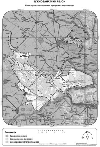
It includes territories in municipalities of Vrsac, Bela Crkva, Kovin and Alibunar. It extends from 45° 12' geographic latitude on north to 44° 44' geographic latitude on south, with altitudes of 70 m to 260 m, but areas where vineyards are, are at altitudes from 90 m to 220 m.
Region is located in predominantly lowland (most common types of soil are vertisol and chernozem, little less arenosol and sirozem on sand stone, and some other types of soil). North east part of the region is dominated by mountain Vrsacke Planine (641 m), which extend due east - west (18 km long), and which provide favorable conditions for growing vine. Vine is also influenced, partially, by the river Danube from south, and vineyards are located under forested Vrsac hill, which all contributes to micro climate.
Vrsac hill is surrounded mostly by forests of oak, Turkey oak, and red oak. In lower belt which includes Pannonian - Pontic forest - steepes, there are also arable crops. Landscape of this part of the region - vineyards of Deliblato sands, is under influence of Deliblato sands like acacia forests. Landscape is also characterized by canal Danube - Tisa - Danube (DTD) which flows through the region, and Lakes at Bela Crkva from east.
Vrsac mountain are protected nature good of Serbia– Area of exceptional characteristics.
Deliblato sands are protected nature good of Serbia – Nature reserve.
South Banat region includes the following vineyards:
2.6.1. Vrsac vineyards – Vrsac,
2.6.2. Bela Crkva vineyards - Bela Crkva, and
2.6.3. Deliblato sands vineyards - Deliblato sands.